The Southern Plains of the United States is rich in cultural history and stirs with the whispers of the spirits who once dominated this region
The rising sun silhouettes a troop of mounted soldiers approaching along the wide expanse of the Canadian River. A Comanche brave watches the tiny figures from the bluff. His pony forages on sweet grass in the canyon far below, in the shade of cottonwood trees. Soon the young warrior scrambles down from his perch and in one lithe movement swings atop his horse, turning toward his village at a gallop. It is 1849.
More than 150 years later I stand aloft at dawn and gaze down to that same stream, now a narrow serpent of gold in the broad river valley. I think of the brave, and the soldiers, and the emigrants they protected along the road to California. This land of open prairie and fiery sunsets looks much the same to me as it did to them. In fact, from here a traveler still could tread untilled soil all the way west to the Rockies.
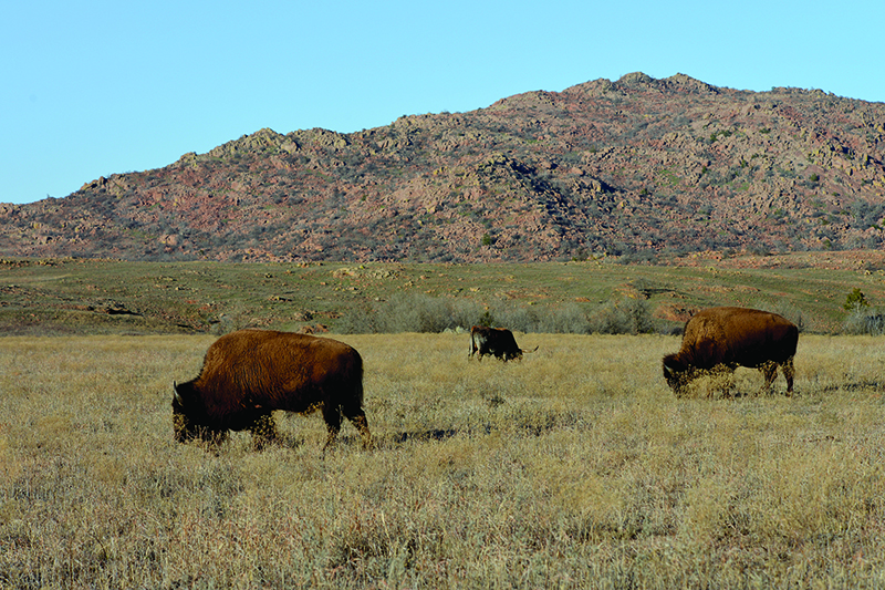
Buffalo, Wichita Mountain Wildlife Refuge, southwestern Oklahoma
This is the land of Comancheria. From their rise to dominance in the 1700’s to their subjugation almost 200 years later, the Comanches ruled this huge parcel of the Southern Plains, centered upon the Llano Estacado and taking in parts of present-day Texas, Colorado, Kansas, New Mexico and Oklahoma, more than 240,000 square miles of territory. They came from the Rocky Mountain country north of the headwaters of the Arkansas to that river’s valley in what is now eastern Colorado and western Kansas about 1700. When history first records their emergence as “Comanches,” they were a small tribe of hunter-gatherers living on the northern frontier of New Mexico.
“It was here,” according to Wallace and Hoebel in Lords of the South Plains, “at the advancing edge of the world’s largest empire, that the Comanches launched an explosive expansion. They purchased and plundered horses from New Mexico, reinvented themselves as mounted fighters, and reenvisioned their place in the world. They forced their way onto the southern plains, shoved aside the Apaches and other residing nations, and over the course of three generations carved out a vast territory larger than the entire European-controlled area north of the Rio Grande at the time. They became ferocious horse-riding warriors who forestalled Euro-American intrusions into the American Southwest well into the late nineteenth century” in what historian Pekka Hämäläinen describes as a story of “reverse colonialism.”
We are here to experience for ourselves the canyons, creeks and grasslands where the Comanches lived, fought and died. Modern explorers can still find a vast emptiness of dirt roads, stream crossings and coyotes in this remote area of the United States. A perfect place to drive, camp and hike as we seek the spirits of the Lords of the South Plains.
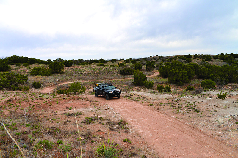
Driving through Sandy Sanders Wildlife Management Area near Erick, Oklahoma
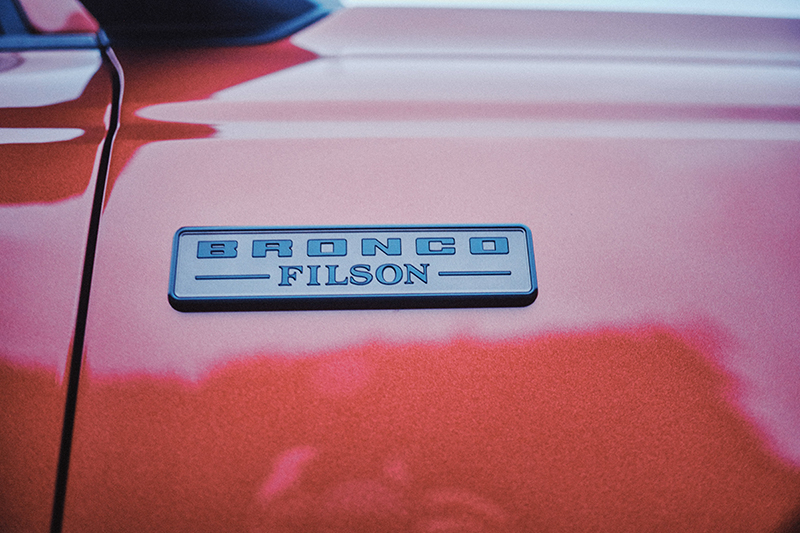
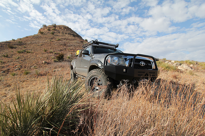
Our mode of travel is a far cry from the horse but nearly as flexible. We have outfitted a 2011 Toyota Tacoma as a four-wheeled version of the versatile Gelande Strasse line of BMW motorcycles, dubbing it the “GS of Trucks.” We will test the validity of that moniker in this rugged country. Our inspiration? A love of history and a constant hunger for the outdoors combined to ignite a full-blown idea for adventure after reading S.C. Gwynne’s popular Empire of the Summer Moon. Gwynne’s bestseller chronicles the rise and fall of the Comanches and the role of Principal Chief Quanah Parker in leading his people’s transition after their surrender to the U.S. Army at Fort Sill in 1875. Our home in Norman, Oklahoma sits on the eastern edge of Comancheria – an easy drive via blacktop to many locations important to the Comanches, but we sought a better way.
Armed with Gazetteers for Oklahoma and Texas, Susan and I head west with cameras and camping gear to string together a dirt “trail” through the Comancheria of western Oklahoma and the Texas Panhandle. Our journey begins after a night at the southwestern Oklahoma home of our friends Chris and Claire Johnson. Their ranch is located on the northwestern edge of the Wichita Mountains Wildlife Refuge and a perfect launching pad for this expedition. The Wichitas are ancient mountains, sculpted through the ages by climatic forces into the knobs and domes of today. They offered the Comanches hiding places, hunting grounds, and encampment. On their eastern edge, within Fort Sill, jut the Medicine Bluffs, a site sacred to the Comanches, a place full of legends.
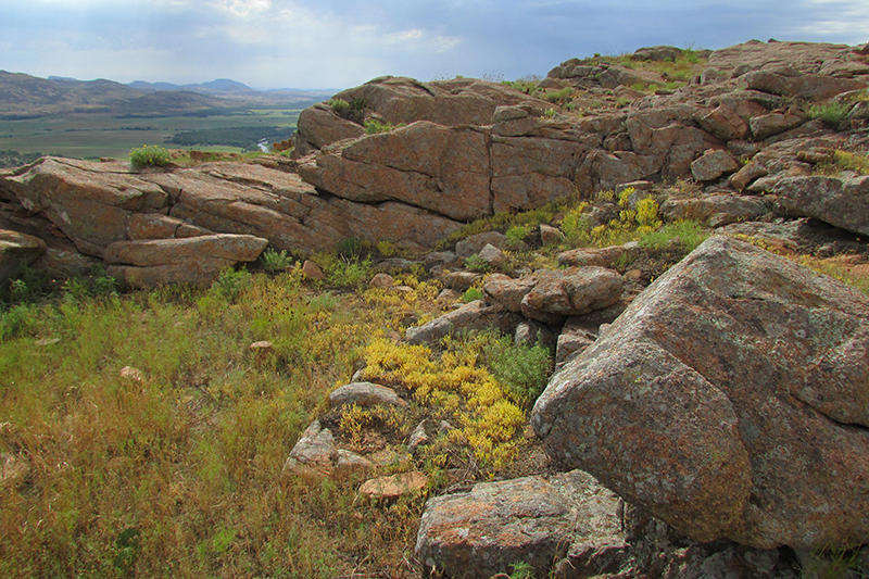
Wichita Mountains
In The Life and Adventures of a Quaker among the Indians (1875), Thomas C. Battey, who served as a teacher and government field agent among the Plains Indians, related this story of Medicine Bluffs:
Many years since, a noted medicine-man of the Comanche tribe, in company with some of his personal friends, in their travels rode up the slope of the hill, when this frightful precipice of two hundred or two hundred and fifty feet appeared before them, stopping them in their course. But the medicine-man was not to be stopped, neither turned aside. Uttering some words of Indian magic, he rode his horse over the precipice; but, to the astonishment of his friends, instead of being dashed to pieces at the bottom, he was gently borne across the chasm to the opposite bank of the stream, where, finding himself alone, he turned his horse to look for his friends, whom he beheld at the top of the bluff, afraid to follow and too proud to go around. To relieve them from their unpleasant position, he rode back to the bottom, crossed the creek, and rode directly up to the perpendicular wall of rock, which rent at his approach, dividing the bluff into two parts by forming a chasm through the cliff several feet in width, through and up which he rode, rejoining his companions at the top, who then followed him down through the pass thus made, now known as the Medicine-man’s Pass. This pass is an inclined passage, twelve or fifteen feet wide, extending through the cliff to the top.
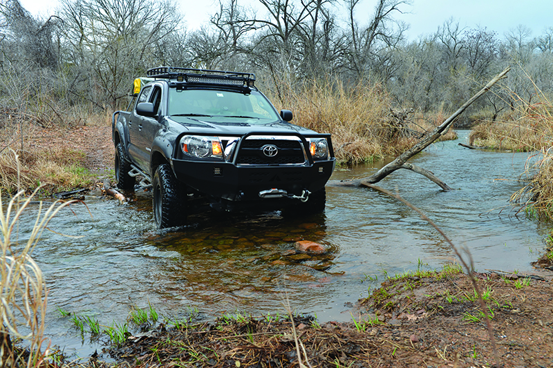
River crossing with the GS
As we stand at the base of the Bluffs, Medicine-man’s Pass is just as evident to us as it was to Battey. We want to see the view from the top; how to get there is a puzzle we are determined to solve, and solve it we do. The truck takes us across creeks and along rutted trails to a locked gate, from which we proceed on foot, arriving at the summit in a strong wind and a light rain. The precipice, actually 320 feet in height, begs a look over the rim, although the wet, knife-edged granite requires extra caution. I brace on the cliff-top against the gale and find the spectacular view well worth the effort. Later we learn that visitors are forbidden to ascend the Bluffs. The adage proves true, “It is easier to ask forgiveness than permission.” Fortunately we got away with the unintended offense and were forced to ask neither.
Leaving the Wichitas, we bid farewell to the Johnsons and strike out in a northwesterly direction, navigating mile by mile with the Gazetteer to stay off pavement. The landscape becomes more open – mesquite and prickly pear dominate the flora here as we transition into the prairie. The occasional butte appears, visible from miles away in the flatness of the plains. Searching the Gazetteer for unpaved roads that will take us through more interesting terrain, we occasionally find a path that diverges from the straight lines typical of Oklahoma roads, which were originally laid out on a grid of one-mile squares. One such curving byway brings us into the Gypsum Hills, a region of buttes that sparkle in the sunlight because of the gypsum they contain, white layers of the mineral also evident at their summits. We travel twisting, high clearance roads through the Sandy Sanders Wildlife Management Area, a broken landscape of canyons and cactus which stands in stunning contrast to the seemingly featureless scenery drivers see from nearby Interstate 40. We set up our Eezi-Awn truck-top tent at one of the few primitive camp sites, a high patch of prairie with a view of the Wichitas to the east, and listen to the coyotes howl through the night. The next morning the wind awakens us, whipping our tent, and we emerge to the sight of dark thunderheads bearing down from the southwest. It’s time to make a quick exit from this vulnerable spot and we waste no time putting away the tent and heading north, allowing the storm to pass to our southeast.
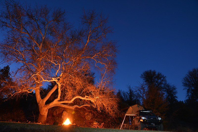
Enjoying a campfire while at basecamp
Working our way deeper into the heart of Comancheria, we pass the occasional abandoned rock school house, old barn or prairie home, still standing in defiance of the ravages of time. Soon we approach the Black Kettle National Grasslands, near Cheyenne, Oklahoma. Here is the site of the Battle of the Washita, where, in 1868, Lieutenant Colonel George A. Custer led the Seventh U.S. Cavalry on a surprise dawn attack against the Southern Cheyenne village of Peace Chief Black Kettle. Custer was in a hurry to execute the attack and get away because Comanches and Kiowas were also camped in the area and were coming to the aid of the Cheyenne. In Custer’s haste he left behind some of his soldiers, who were massacred. It is said that the hatred for Custer harbored by his subordinates over this incident was a major factor in their failure to go to his aid at Little Bighorn.
The Grasslands also preserve a significant remnant of the mixed-grass prairie so important to the Comanches, providing food for the buffalo herds which, along with horses, comprised the engine of their economy and foundation of their culture. Our good fortune continues with an unpaved road leading us on a diagonal through the Grassland. We stop to explore a ruin of blood red stone and climb atop a nearby outcropping for a view across the plain, northwesterly towards the Antelope Hills.
These buttes were landmarks for early travelers and often mentioned in their accounts, this one from U.S. Army Captain and western explorer Randolph Marcy from his 1849 journey from Fort Smith to the California gold fields:
This morning we followed down the creek, and travelled for several miles upon the Canadian; finding this part of our road sandy, however, we soon turned back, and came upon the high prairie between two of the Antelope buttes. These hills are about one hundred and fifty feet high, of porous sandstone, and appear to be the result of volcanic action. They rise almost perpendicularly from the smooth prairie, are flat upon the top, and present every indication of having been raised out of the earth by volcanic agency. They are near the 100th degree of longitude, and are sometimes called the Boundary mounds, as being near the line formerly claimed by Texas as her eastern boundary.
Antelope Hills in western Oklahoma
The Antelope Hills are perhaps best known as the site of a significant 1858 battle in which Texas Rangers, led by Captain John “Rip” Ford, attacked a Comanche village on nearby Little Robe Creek, changing the face of Indian fighting on the plains. For the first time, Texan or American forces penetrated to the heart of Comancheria, attacked Comanche villages with impunity, and successfully returned home.
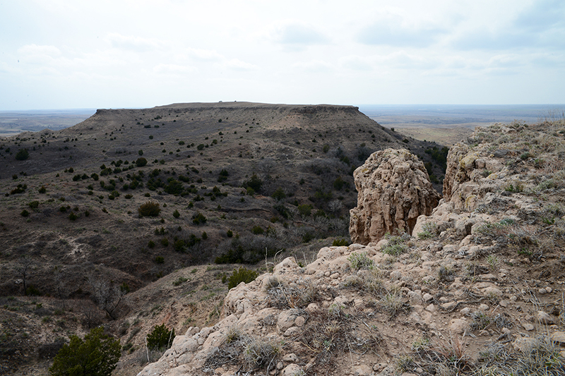
On foot, it’s a scramble to the summit of the Hills’ northernmost peak over rough, porous, sometimes crumbling rock. At 2,600 feet, they are diminutive compared with their rocky neighbors to the west, but here in the flatness of Oklahoma they tower over the surrounding plains. Inches from the edge, we shelter from the stiff south wind in the lee of a stand of cedars and imagine abiding in this spot as sentinels in the mid-19th century. In every direction the view is a scene from a Hollywood western, lacking only the tiny dust cloud on the horizon betraying the approach of an enemy.
The Taco in Antelope Hills, western Oklahoma
Here I realize that I am gradually learning to see the land for what it was, for what it meant to a people. The river I once barely glimpsed from the highway bridge and the familiar silhouette of a butte in the distance — their significance is fresh and new. They no longer depend on modern man and his deeds, his fences, signs and structures, for definition. I am reaching for a world that was here, is here, right under my feet, but whose meaning I must rediscover. This thought remains as we divert from our loop to experience a part of this country consciously preserved. Following roughly the course of the Canadian River, we scurry along dirt roads through the Packsaddle Wildlife Management Area to Four Canyon Preserve.
“You could walk from here to the Rocky Mountains on native sod,” says Chris Hise, preserve director, supporting his assertion with a map of Untilled Landscapes of the Great Plains. The 4,000-acre Nature Conservancy property is a gem of a wild place in Ellis County, Oklahoma, a rugged landscape kept in a state as close as possible to pre-European settlement. Deep canyons and high prairie ridges make for challenging hiking, and a high clearance road leading down to the Canadian River facilitates our goal of giving the truck a shakedown. The red clay accumulates on our tires as we pass the corral and wellhead of an abandoned homestead. Arriving on the flood plain, we picnic in the lush grass under a grove of cottonwoods and I nap in the shade, an activity that has value no matter the century.
At the Adobe Walls Battlefield Site, Texas Panhandle
Soon we resume our westward journey, forced to jump on the pavement to make our way to Adobe Walls, Texas, once a trading post near the Canadian River and the site of two significant battles in the Plains Indian Wars. The first, in 1864, saw Colonel Christopher “Kit” Carson leading 335 soldiers and 72 Indian scouts against a force of more than 1,000 Comanche, Kiowa, and Plains Apache. The Indian army forced Carson to retreat though he was acclaimed a hero for successfully striking a blow against the Indians and for leading his men out of the trap with minimal casualties. Ten years later, the Second Battle of Adobe Walls was fought between Comanche forces led by Quanah Parker and medicine man Isa-tai, and a group of 28 U.S. bison hunters defending the settlement. The battle ended when the Indians withdrew, but it led to the Red River War of 1874–75, which resulted in the final relocation of the Southern Plains Indians to reservations in what is now Oklahoma.
We cross the Canadian River south to north on a historic bridge near the town of Canadian, Texas and return to dirt when we pick up the River Road, traveling 50-some miles along the Canadian River. Our Icon Suspension-equipped Tacoma was well suited for these fast and winding roads, allowing us, like the Comanches, to cover ground quickly, throwing up clouds of white dust as we drift through the occasional sharp corner. After much zigging and zagging, we finally locate Adobe Walls at the end of a dead-end road and are disappointed to find nothing but prairie, a jack rabbit, and two granite monuments commemorating the combatants on both sides. It takes only a little imagination, however, to picture the Indians attacking from the nearby hills and their frustration at being picked off by the well armed bison hunters from within the stockade.
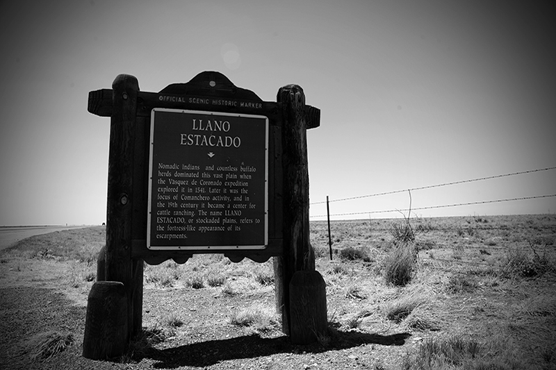
Llano Estacado sign, eastern New Mexico
Turning south, we find ourselves upon the Llano Estacado, commonly known as the Staked Plains but perhaps more accurately interpreted as the “palisaded” plains in geological terms. A high mesa sloping toward the southeast and one of the largest tablelands on the continent, the Llano covers approximately 32,000 square miles, an area larger than New England. It is distinctly bounded on the north by the southern escarpment of the Canadian River valley and on the east by the irregular and deeply incised Caprock escarpment.
The Llano Estacado was first described by Francisco Vázquez de Coronado in a letter to the king of Spain in 1541: “I reached some plains so vast, that I did not find their limit anywhere I went, although I travelled over them for more than 300 leagues . . . with no more land marks than if we had been swallowed up by the sea . . . there was not a stone, nor bit of rising ground, nor a tree, nor a shrub, nor anything to go by.” Marcy, who led an expedition to explore the headwaters of the Canadian and Red Rivers in 1852, echoed Coronado’s impressions of the region: “It is much elevated . . . very smooth and level . . . without a tree, shrub, or any other herbage to intercept the vision . . . the almost total absence of water causes all animals to shun it: even the Indians do not venture to cross it except at two or three places.”

We travel southwest across the Llano on long, dusty roads which indeed seem to go on forever, dodging tumbleweeds and navigating along “county roads” which sometimes become nothing but ruts along fence lines. The truck soaks up the rough terrain, living up to its Gelande Strasse namesake. Vestiges of abandoned homesteads appear from time to time in the form of rock foundations, rusted iron farm implements and rickety windmills. We also see new windmills of the old design in active use. Some good things last, it seems.
On the Llano Estacado’s eastern escarpment just south of Amarillo, Palo Duro Canyon is one of the most spectacular landscapes in Texas. Claimed to be the second largest canyon in the U.S. after the Grand Canyon, Palo Duro rivals its larger cousin for scenery. Indeed, its ease of access makes it a highly desirable alternative. Here we see the intense oranges, reds, and yellows of the Caprock escarpment carved into pinnacles, buttes and mesas by the headwaters of the Prairie Dog Town Fork of the Red River. The canyon extends 60 miles, reaching depths of 800 feet and average widths of more than six miles. The painter Georgia O’Keeffe, who lived nearby early in the 20th century, wrote of the Palo Duro: “It is a burning, seething cauldron, filled with dramatic light and color.”
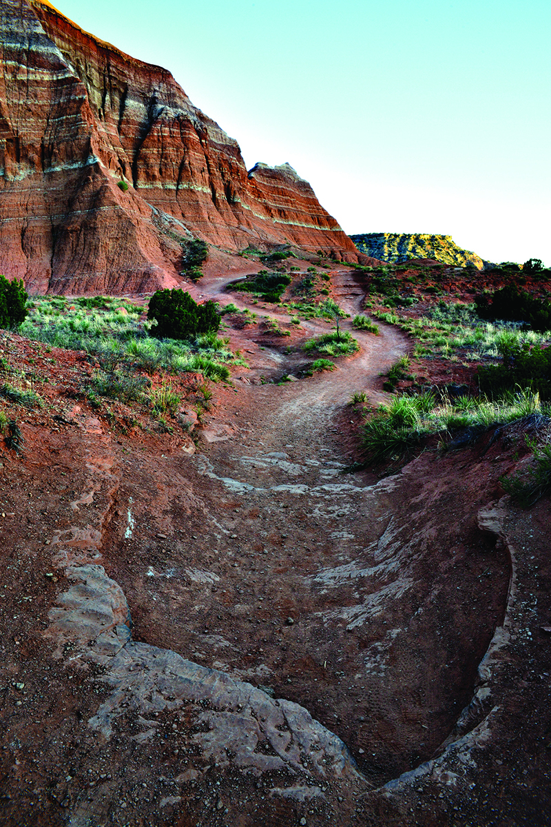
Lighthouse Trail, Palo Duro Canyon
In the 18th century, after the Plains Indians had acquired horses, the canyon became a major campground of the Comanches and their allies, who continued to camp here until 1874, when U.S. Cavalry troops under Colonel Ranald S. Mackenzie made a surprise dawn attack on a large encampment. It was a decisive victory for Mackenzie and represented the Southern Plains Indians’ last effort at military resistance against the encroaching whites.
We camp in Palo Duro and hike early the next morning to the Lighthouse, a 310-foot-high pedestal rock. Our early morning departure saves us from the heat of the day. After our hike we picnic and pack up, traveling southeast along winding dirt roads and over the edge of the Caprock, through ranch lands and over cattle guards. We slow as we approach a ranch house or a herd of cattle out of courtesy to the rancher and safety for both us and the cows. Crossing a broad plain, we come upon the Llano Estacado’s eastern escarpment once more at Caprock Canyons, another dramatic and colorful landscape startlingly unlikely in the Texas Panhandle.
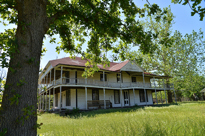
A view of Quanah Parker’s Star House
Our journey ends with a pilgrimage to the Star House, final home of Quanah Parker. Located in Cache, Oklahoma, on the southern edge of the Wichita Mountains, it was built around 1890 for Quanah with the help of Texas cattlemen, a testament to the respect he commanded. Quanah, the son of a white woman who was captured by Comanches in the 1830’s and Comanche leader Peta Nocona, balanced his role as leader of his people with his function as an emissary to white culture. He entertained notables as diverse as Geronimo and British Ambassador Lord Bryce at the long dining room table still present in the deteriorating structure.
A tour of the house requires an appointment and a visit to a trading post on a lonesome highway intersection, from whence we are led into the ghost town of Eagle Park, an abandoned amusement park to which the Star House was moved in the mid-20th century. We are allowed to walk through and photograph the parlor, dining room, and bedrooms on the first floor, but the upper story is inaccessible, and likely dangerous because of the building’s poor condition. The roof and walls are sagging, but the building retains a haunting beauty, crouched in the deep green grass canopied by cottonwoods. It reminds us of the natural wonders we have just seen, seemingly eternal and little changed, contrasted with the fleeting life of things manmade.

Comancheria is more than a place. It is a time, an era when fierce men and stout women wove their lives into nature. It was a brief time, really, when the Comanche took their turn as Lords of the South Plains and carved their heritage forever into the pages of history. Today’s overlander can still go there and commune with their spirits, in the heart of Comancheria.
OutdoorX4 Magazine – Promoting responsible vehicle-based adventure travel and outdoors adventure