Big Bend National Park
“There are no words that can tell the hidden spirit of the wilderness, that can reveal its mystery, its melancholy and its charm.” – Theodore Roosevelt
Along the U.S. southern border is a place where the limestone has been carved from the basement of time. Its isolation is so vast that at night, clear skies give the illusion you can see all the way to the ends of the universe with bright stars blanketing the dark. It is home to a myriad of diversity, from its varied geologic wonders to its wild inhabitants. This place is a haven for adventure and exploration. This place is Big Bend.
Big Bend
Texas’ Big Bend region is a hidden gem for adventurers seeking to get off the beaten path. Located along the Texas – Mexican border and encompassing over 801,000 acres, Big Bend National Park is a seemingly inhospitable environment with the Chihuahuan desert, along with the Chisos Mountains, comprising its broad expanse. Additionally, numerous flora and fauna inhabit the region including over 1300 plant species, 65 taxa of cacti, sotol, various types of shrub and grassland as well as mule deer, roadrunners (also known as Paisano), jackrabbits, javelinas, tarantulas, mountain lion, black bear, 175 species of butterflies and over 450 species of birds. The diverse eco-system of the park is truly special.
“This was going to be a fun journey even though it meant driving across the entire state of Texas to get there.”
Thus it comes without saying a visit to Big Bend had been on our minds for quite some time. Who wouldn’t want the opportunity to travel across the Lone Star State and explore such a broad and diverse environment? So, we planned out our trip several months in advance and as the weeks turned into days and the days turned into hours before departure, the family and I did a complete breakdown of all the gear we had loaded for the trip and then we were on our way. This was going to be a fun journey even though it meant driving across the entire state of Texas to get there.
Getting to Big Bend is half the experience but then again, most everything in Texas is. The state’s rich history and culture lends itself to unique perspectives and plenty of side excursions along the way. Since we were traveling from the east, our journey included travel through San Antonio, a city made famous by the Alamo and the valiant battle fought by 189 Texian defenders in the midst of the Texas Revolution, all of whom lost their lives during a 13-day siege by the Mexican army. The city and its rich cultural diversity are a testament to this battle and Mexico’s influence still reigns strong there. San Antonio is a city certainly worth spending time in as a travel destination with its referenced culture, excellent food, and world-famous Riverwalk which runs through the middle of the city.
“…unidentified immigrant remains whose journey from beyond the southern border came to an abrupt end…Their untold stories, regardless of consequence, are tragic reminders of how inhospitable the desert can be.”
Our journey continued through Texas’ hill country with especially long stretches of nothing but hills and pavement. It is along this stretch you start to realize just how expansive the state of Texas is and how remote its destinations can be, particularly as you travel further west. We eventually arrived in Fort Stockton, the gateway to Big Bend, where we fueled up and began our southward journey towards the entrance to the park, located an additional 120 miles away. As the journey continues, you’ll begin to approach the northern-end of the Chihuahuan desert which is the “wettest” of the four North American deserts. This is relative though since the area rarely receives more than ten inches of rainfall annually. Of course, on the last day of our adventure the desert air was thick with irony as it rained that entire day.
For this particular trip, I wanted to give my family a grand tour of the park which would include camping along River Road, hiking to the Mariscal Mine as well as through Santa Elena Canyon, and traveling along a broad stretch of the parks numerous off-highway trails including Black Gap Road which is the only four-wheel drive trail in the park.
River Road runs east and west through the park and connects Castolon to Rio Grande Village. The road is primitive and unmaintained but not overly technical. It is an excellent way to see the park along its southern border in a four-wheel drive vehicle with numerous primitive campsites along the way. We chose to spend our first night along the eastern portion of the trail near a camp area called the Gravel Pit. Its name, as you can guess, is reflective of the terrain you’ll find there with plenty of loose limestone scree and broken rock. Our campsite was perfect and the clear, dark sky was breathtaking as we setup camp and gazed at the stars before falling asleep under brisk conditions. Speaking of the clear, dark sky, Big Bend National Park was designated as a Dark Sky Park by the International Dark-Sky Association in 2012 which makes it only the second U.S. national park – and one of only ten parks in the world – to earn this distinction. For the star-gazers out there, this is another incentive to travel to west Texas.
The next morning the sun rose above the mesas to the east and blanketed Big Bend’s topography with a gentle sunlight. Varying types of succulents and sotol glistened with the birth of a new day. My mother, who had never camped in the wilderness before, awoke with sheer excitement as the beauty of Big Bend had completely engulfed her while gazing at the stars the night before and observing the peacefulness at sunrise. We began preparing breakfast which consisted of a simple recipe for sweet potato pancakes and once we were fueled, we tore down camp, repacked the Jeep, and began our day-long journey through Big Bend’s backcountry.
We began our journey that day by turning back and traveling along Old Ore Road which had been used over 100 years earlier to transport ore from Mexican mines to the railroad station at Marathon. This section of Big Bend is also home to several markers which were placed for unidentified immigrant remains whose journey from beyond the southern border came to an abrupt end due to dehydration, starvation, and heat exhaustion. Their untold stories, regardless of consequence, are tragic reminders of how inhospitable the desert can be. The road stretches nearly 26 miles in length though we chose to travel approximately 10 miles before turning back and rejoining River Road East. Once we were back on River Road East, we continued our journey en route to the Mariscal Mine.
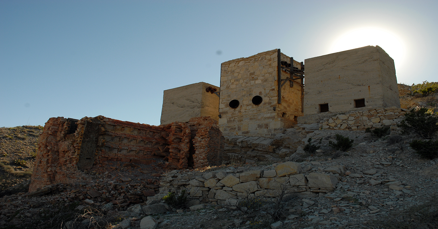
The Mariscal Mine is a unique feature located in a remote area near the middle of Big Bend. The mine, which was abandoned in the early 1940s, is the best preserved mercury – also known as “quicksilver” – mining site in the state of Texas and is even registered with the National Register of Historic Places. Once you arrive, there are some interesting opportunities for exploration which most anyone can enjoy including a relatively short ½ mile hike to the mine and easy access to several of the abandoned buildings located along the mine’s perimeter. The hike is mild as proven by my four-year old daughter who insisted on walking the entire way.
Upon arrival to the mine itself, you’ll find remnants of old mine shafts which were used to excavate cinnabar ore and then transferred via burros to the nearby Chisos Mine for refining. While the mine shafts have since been closed to prevent anyone from accidentally entering and falling into them, they are a reminder of how important, even if for only a short while, the mining business was in this region during the early part of the 20th century.
Once we were back at the Jeep we continued along River Road heading west for several miles until we arrived at the junction for the Black Gap Road.
The Black Gap Road is 8.5 miles long and connects River Road to the Glenn Springs Road. It’s the only trail in the park with sections requiring four-wheel drive which makes it a short but very enjoyable and highly recommended area to travel while at Big Bend. The views along the trail, with the Chisos Mountains to the west and the mesas of the Sierra del Madre to the east, are spectacular and captivate the soul while the body jostles up and down from the rocky terrain. Once you complete this section you’ll arrive at the junction for Glenn Springs Road which continues in a northward direction for approximately eight miles before ending at the main causeway leading west to the Chisos Basin or east to the Rio Grande Village.
Editor’s Note: This article was previously featured in Issue #1 of OutdoorX4 Magazine.
We had decided, prior to our departure towards Big Bend, to spend our second evening at the Chisos Mountain Lodge and enjoy a meal at the connecting restaurant within the Chisos Basin. While it would have been my preference to spend the remainder of our journey in the backcountry, I couldn’t debate the idea of a warm shower and comfortable bed – along with a very fulfilling chicken fried steak at the restaurant topped off with peach cobbler a la mode – that second evening. Plus, if there’s one thing I’ve learned in my travels it is that traveling with the family sometimes means a little “sacrifice” in order to keep the wife, kids, and mother happy. This was no exception.
The next morning we awoke to a big surprise: rain. As noted earlier, the Chihuahuan desert is known for being the “wettest” of North America’s deserts with approximately ten inches of rainfall each year. However, we didn’t expect rain based on reviewing the weather forecast prior to our trip so when it started to rain – and rain it did! – we were caught a little off-guard. However, we weren’t about to let this affect our plans to visit the Santa Elena Canyon for one last hike before our return trip to Houston so we packed our bags, left the Chisos Mountain Lodge, and drove approximately 45 minutes to Castolon en route to the Santa Elena Canyon. Once we had arrived at Santa Elena Canyon, the rain had not subsided and when coupled with the cool mountain air, a layer of fog began to elevate near the rim of the canyon.
Santa Elena Canyon is one of the most beautiful areas of the park with cliffs that tower nearly 1,500 feet and keep guard over the meandering Rio Grande. There are numerous opportunities for adventure including hiking the Santa Elena Canyon trail or, for the more adventurous, traveling by kayak or boat down the Rio Grande through the canyon with a two-mile stretch known to be quite technical with Class IV rapids, depending on water levels. Since it was raining and we had limited time before ending our journey, we chose to hike most, but not all, of the 1.7 mile roundtrip trail before returning to the Jeep right before the rain turned into a torrential downpour. Despite the weather, this is a trail I highly recommend to any visitor of Big Bend.
Once we had changed clothes and topped-off our fuel tank at Panther Junction, it was time to begin the long journey back to civilization. Big Bend National Park, with its expansive desert and formidable mountain terrains, is a true splendor in the vast openness that comprises west Texas. For months we had awaited our journey to this adventure haven and after having spent three remarkable days in the Big Bend region, there’s no doubt our minds will continue to be bound for the Rio Grande.
* OutdoorX4 Magazine – Promoting responsible 4×4 adventure travel and outdoor recreation